RESEARCH
PHOENIX-UASL
![]()
Introduction
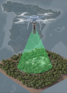
UASL in operation (image created using AI, prompt by A. Pecci, using Gemini)
The adoption of remotely piloted aircraft (RPA, UAS, drones) in archaeology represents a major innovation, one that is still rapidly evolving and whose potential is far from fully explored. Recent advancements have introduced UASL (LiDAR-equipped UAS), which enable the scanning of entire landscapes and the virtual removal of obstacles such as vegetation or modern structures. This capability allows researchers to read topographical details with much greater precision and to detect archaeological features that would otherwise remain hidden.
Historically, despite the acknowledged value of LiDAR, its use aboard crewed aircraft was limited by very high operational costs and by low scan resolutions that only captured the most prominent landforms. Today, thanks to a significant reduction in cost and a marked increase in versatility, UASLs make it possible to generate very high-resolution digital terrain models, capable of recording even micro-topographic variations. Although initial studies are promising, scientific research is still at an early stage, and clear methodological guidelines for both the deployment of these tools and the interpretation of resulting datasets are still lacking.
Against this backdrop, the main goal of the project «PHOENIX-UASL» (Research on PHOENIcian-punic sites in Andalusia with eXperimental Unmanned Aerial System with Lidar) is to test these emerging technologies across selected case studies. Beyond assessing their practical potential and limitations, the project aims to integrate the results into broader landscape archaeology approaches, contributing to long-term historical reconstructions of the investigated areas. The research focuses particularly on key archaeological sites in Andalusia (Spain), including the walled Phoenician-Punic settlement of Castillo de Doña Blanca and Cerro del Castillo (Cádiz), as well as indigenous centers in the Bay of Cádiz.
State of art and project research
Among the most recent remote sensing methodologies successfully applied to archaeological research are proximity analyses conducted with UAS (Unmanned Aerial System). These systems have become extremely valuable—and now almost indispensable—in scientific investigation thanks to their considerable potential and operational versatility. In practical terms, drones make it possible to:
– capture very high-resolution images, surpassing those currently obtainable via satellite or aircraft, and at specific times of the year and day;
– employ low-cost, low-impact equipment;
– perform photogrammetric surveys of entire areas, enabling the creation of 3D models through photogrammetry-based software;
– mount different sensors (RGB, thermal, multispectral cameras, LiDAR) depending on the requirements of a given investigation.
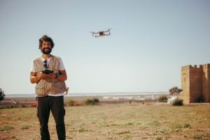
Antonio Pecci during data acquisition by UAV on Doña Blanca (photo by Manu García https://www.lavozdelsur.es/ediciones/provincia-cadiz/el-puerto/universidad-cadiz-arqueologo-italiano-pionero-drones-pompeya-dona-blanca_343639_102.html)
UAS are rapidly evolving technologies, becoming increasingly powerful especially in terms of sensor performance and quality. Among the most innovative recent advances in R&I within this sector are drone-based surveys equipped with LiDAR (Laser Imaging Detection and Ranging). This technology allows the scanning not only of individual objects but of entire landscapes, enabling researchers—during post-processing—to visualize the bare terrain surface by virtually removing vegetation and anthropic elements. This provides a clearer topographical reading and facilitates the identification of archaeological features. In the past, LiDAR mounted on crewed aircraft proved to be an effective archaeological tool; however, its use remained limited due to prohibitive costs and the relatively low resolution of the resulting digital terrain models, which typically highlighted only major topographic structures such as fortifications or urban districts.
Today, with sharply reduced costs, hardware miniaturization, and improved drone aerodynamics, it is possible not only to equip a UAS with LiDAR, but also to obtain centimeter-level resolution data capable of capturing micro-topographic features such as domestic buildings, necropolis areas, and isolated structures. Yet despite this significant potential, pioneering studies remain limited. While a general handbook on the use of drones in archaeology is available—recently published by the researcher PhD. Antonio Pecci—there are no dedicated manuals for UASL (Unmanned Aerial System–LiDAR) nor standardized protocols for data interpretation. Similarly, best-practice examples and scientific publications that compare different LiDAR sensors or acquisition and processing methods are still scarce.
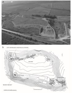
Castillo de Doña Blanca (El Puerto de Santa María, Cádiz) (from A.M. Niveau de Villedary y Mariñas, Gadir in the 5th century BC. Restructuring city and territory, in A. Roppa, M. Botto, P. Van Dommelen, Il Mediterraneo Occidentale dalla fase fenicia all’egemonia cartaginese. Dinamiche insediative, forme rituali e cultura materiale nel V secolo a.C. (215-227), Roma 2021, 218, fig. 2
Building on the scientific and professional background of the researcher, and following the trajectory of his PhD research—focused on fortifications and defensive systems between the 4th and 3rd centuries B.C. in Basilicata (Italy), where both drone-based and airborne LiDAR applications were extensively employed with excellent results—he intends to continue developing this line of inquiry. The goal is to take a further and ambitious step within the field of drone-supported archaeological research, using advanced and innovative technologies and contributing to progress in the discipline through the production of an application protocol.
In this framework, the inter-multidisciplinary project PHOENIX-UASL “Research on PHOENIcian-punic sites in Andalusia with eXperimental Unmanned Aerial System with Lidar” was conceived. It centers on the study and experimentation of UASL on selected case studies well suited to this type of investigation, in order to evaluate both their potential and their limitations. The expected results will complement traditional landscape archaeology methods and support the diachronic reconstruction of archaeological sites.
The project was established in close collaboration with the research group HUM509 – PHOENIX MEDITERRANEA at the Department of Historia, Geografía y Filosofía of the University of Cádiz (UCA), led by Ana María de Niveau de Villedary y Mariñas, who serves as supervisor for this project. The group—named after the Greek term used to designate the Phoenicians—has long been involved in the study, dissemination, and promotion of the historical, archaeological, and cultural heritage of Western Andalusia.
In this project, PHOENIX-UASL aligns closely with the broader Andalusian project and its research objectives while simultaneously evoking both the mythological phoenix and UASL technology, symbolizing a union of historical inquiry and scientific innovation. As noted, the research will focus on a selected set of case studies previously examined in a preliminary and preparatory scientific investigation carried out by the researcher. These include key archaeological sites in Western Andalusia (Spain) in the Bay of Cádiz, such as the Castillo de Doña Blanca (El Puerto de Santa María).
Main objective and methodology
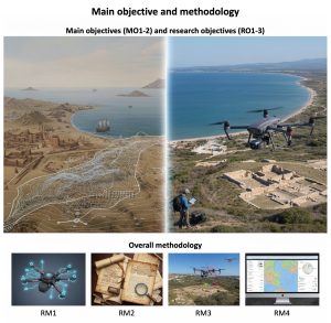
Main objective and methodology (image created using AI, prompt by A. Pecci, using Gemini)
Main objectives.
PHOENIX-UASL aims to investigate and experimentally apply UAS-LiDAR (UASL) technologies across selected case studies in the Bay of Cádiz that are particularly well suited to such analyses. The goal is to assess their potential and limitations, generating results that complement traditional approaches in landscape archaeology and contribute to the diachronic reconstruction of past environments. In summary, the project seeks to pursue two Main Objectives (MO), whose developmental trajectories are detailed in the following section:
MO1. A methodological assessment concerning the application and experimental use of UASL in archaeological and landscape investigations.
MO2. An examination of the historical, topographical, and environmental dimensions of the case studies, aimed at reconstructing their diachronic evolution.
Specific objectives.
The Research Objectives (RO) are as follows:
RO1. To analyse the various case studies in order to understand settlement patterns, human–environment interactions, and the natural and anthropogenic transformations produced over time, from Prehistory to the Early Medieval period.
RO2. To conduct archaeological analyses based on field surveys and GIS-based interpretation, with the aim of contextualizing and integrating the data within existing scholarly debates and historical knowledge.
RO3. To develop an innovative methodological approach to landscape archaeology and topographic surveying grounded in the use of UASL.
PHOENIX-UASL adopts four Research Methodologies (RM), summarized below. The first two rest on a general methodological framework, while the latter two focus on the integration of disciplinary approaches necessary to achieve the project’s goals and expected results.
Overall methodology
RM1. A technological study and in-depth analysis of UASL. This includes research on surveying instruments (UAS and LiDAR), acquisition protocols (flight planning, scanning parameters, etc.), data management (software, specific applications), processing methods (algorithms, mathematical models), and data interpretation. The methodology is grounded in extensive technical literature and comparison of scientific publications. Given the interdisciplinary nature of the project—drawing on remote sensing techniques from engineering, geophysics, geology, and related fields—additional technical training will be pursued through courses offered by international training centres.
RM2. Bibliographic, historical, and topographical research on the archaeological sites under investigation. This involves analysing each case study, producing catalogue records, and critically reassessing their diachronic, typological, and functional development from the Archaic period (8th century BC) to Early Romanization (3rd–2nd century BC). The objective is to construct a coherent interpretive framework for the sites. This process is not a mere transfer of data into a digital system but requires continuous critical engagement with the documentation, recontextualization of evidence, and identification of interpretive challenges.
Integration of methods and disciplines to achieve the objectives
RM3. Experimental UAS-LiDAR surveys of the case studies using various techniques and operational methodologies, with the aim of critically comparing the resulting datasets. Data acquisition will integrate classical remote-sensing tools, recent technological developments (drone-based surveys and 3D photogrammetric modelling), and cutting-edge UAS-LiDAR systems. This multifaceted approach is essential both for conducting archaeological surveys and for objectively assessing the potential and limitations of each instrument and methodology.
RM4. Analysis and interpretation of UASL-derived datasets to identify archaeological features and contextualize the sites historically and topographically. Following UASL acquisition, the data will be interpreted with respect to each case study, integrating the results with traditional archaeological evidence. The outcomes of UASL experimentation will thus complement conventional archaeological research and contribute to the diachronic and topographical reconstruction of the sites. The combined methodologies and interdisciplinary framework aim to produce a model transferable to other territorial contexts, beyond the Andalusian region and the specific case studies examined here.
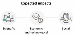
Expected impacts of the project
The project aims to investigate selected case studies in the Bay of Cádiz that have been of interest to archaeologists for decades, employing an innovative approach and methodology based on the use of UAS-LiDAR (UASL). Consequently, it is anticipated that the results, disseminated and valorized according to the plan outlined above, will have a significant impact on both the scientific community studying Phoenician-Punic sites in Andalusia and on researchers exploring the applications of drones in archaeology.
In summary, the expected impacts of the project are:
-
Scientific impact: The project will enhance understanding of the Andalusian case studies, establishing a reference point in topographical research on these sites. For the first time, UASL technology will be applied to these key sites in the Bay of Cádiz, providing new insights and methodological innovation.
-
Economic and technological impact: The project will foster new operational processes and increase the productivity of these technologies by integrating UASL equipment into archaeological research. It will also contribute to the definition and improvement of standards, protocols, and best practices for the use of such tools.
-
Social impact: The project will promote greater awareness and understanding of archaeological contexts, benefiting both the scientific community and local populations, and reinforcing the value of cultural heritage in the region.
Expected Impacts (image created using AI, prompt by A. Pecci, using Gemini)
Workplane

Illustration of the workplane concept (image created using AI, prompt by A. Pecci, using Gemini)
The workplan consists of Work Packages (WP), Deliverables (D) and Milestones (M), below in synthesis:
WP1. Project management
(D.1.1-3, M.1)
WP2. Training activities
(D.2.1-4, M.2)
WP3. Data collection
(D.3.1-4, M.3)
WP4. Archaeological mapping
(D.4.1-2, M.4)
WP5. Applications of remote sensing techniques
(D.5.1-3, M.5)
WP6. Historical interpretation of individual sites and landscape
(D.6.1, M.6)
WP7. Dissemination of the project and results
(D.7.1-5, M.7)